Blog
Leveraging the Latest Geospatial Technologies to Advance Wetland Identification
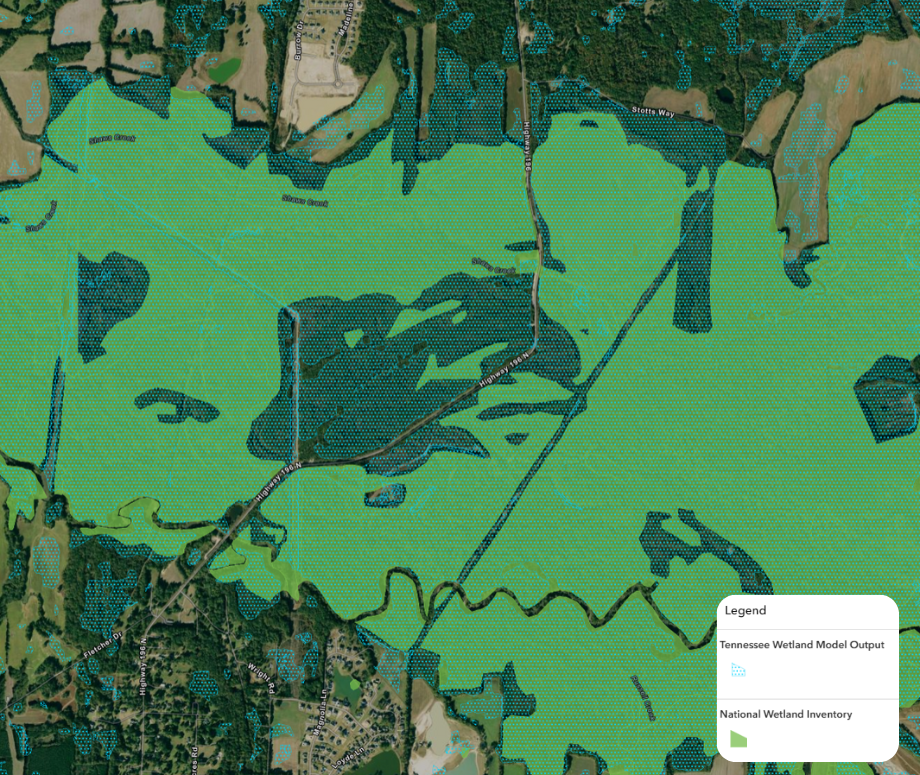
Wetlands provide crucial ecological benefits from water filtration and flood mitigation to wildlife habitat and carbon storage. Currently, the most comprehensive and authoritative spatial wetland dataset for Tennessee is the National Wetland Inventory (NWI), which largely relies on data that is 40-50 years old. Given the rapidly changing landscape and the uncertainty regarding the jurisdictional status of wetlands, it is imperative that the current locations and extents of wetlands throughout the state be documented. Yet, identifying these areas can be complex and resource-intensive, especially over large regions. To address this, Skytec LLC in collaboration with the Tennessee Department of Environment and Conservation (TDEC) developed the Wetland Screening Tool for the State of Tennessee. This tool provides an interface where the end user can explore the results of a wetland model that utilizes machine learning and up to date high-resolution geospatial data to streamline the process of locating and approximating the extents of potential wetlands across the landscape.
Modeling Wetlands in Tennessee
This initiative leveraged an enhanced version of the Esri Arc Hydro Wetland Identification Model (WIM) that was optimized for large-scale application across statewide geography. The enhanced model also integrates advanced Deep Learning tools to accurately recognize wetland features in aerial or satellite imagery. Key inputs for the model included LiDAR-derived predictor variables, high-resolution imagery, and approximately 75,500 acres of meticulously curated wetland training data.
The development of this model was a collaborative effort that relied upon input from regulatory agencies, regional scientists, and nonprofit organizations. Technological partnerships with Esri, Microsoft, and Planet Labs were crucial to the success of this project given its scale and the required computational resources.
While the predictive model does not definitively confirm the presence or absence of jurisdictional wetlands or precisely delineate their areal extent, it does identify the areas where wetlands are likely to occur based on what is learned from the model inputs. The data derived from this modeling effort suggests that NWI data significantly underestimates the extents of wetlands within the state. It is our hope that this dataset can serve as a foundational layer that can inform future updates to the NWI dataset.
Wetland Screening Tool Overview
The screening tool provides an overview of the modeling efforts and interactive maps where the end user can explore the predictive model outputs within their areas of interest. Additionally, the screening tool provides insights into areas where future wetland restoration efforts may be focused and the locations and extents of isolated wetlands across the state. Potential applications for the screening tool include:
Environmental Planning and Due Diligence – Allows for a more detailed desktop review of proposed infrastructure or development project areas to assess site suitability or the potential for avoidance and minimization of wetland impacts
Conservation Initiatives – Suggests areas that may support unique aquatic habitats that should be prioritized for preservation or ecological restoration
Regulatory Compliance – Allows for a more streamlined environmental review and permitting process
Leveraging Remote Sensing and Advanced Technologies
Skytec maintains a decade of experience in delivering innovative geospatial solutions that integrate LiDAR and imagery across diverse scales, multiple software environments, and robust cloud compute resources. This expertise allowed Skytec to train, process, and efficiently deliver wetland prediction models for an entire state in a matter of months, versus the traditional mapping requirements of 1 – 3 years. In addition to the enhanced modeling approach, Skytec leveraged the satellite remote monitoring capabilities of Ranger to detect changes on the landscape that occur on or near predicted wetlands. This comprehensive solution for mapping and then monitoring wetland resources with AI, GIS, and satellite imagery is unique in the geospatial industry.
Commitment to Responsible Stewardship
Skytec remains dedicated to supporting effective land management through reliable, data-driven solutions. By integrating geospatial technology with a focus on conservation, we aim to help our partners efficiently locate, understand, and protect these vital ecosystems.
For more information on our Wetland Screening Tool or wetland mapping services view the project fact sheet or contact us.
View the Wetland Screening Tool.

Skytec Blog

Leveraging the Latest Geospatial Technologies to Advance Wetland Identification
Launching Skytec’s Wetland Screening Tool for the State of Tennessee
Read More
Using GIS to Lead in Sustainable Supply Chain Management
At Skytec, we’re proud to partner with industry leaders like International Paper to develop innovative, GIS-based solutions that address complex challenges in sustainable sourcing and supply chain management.
Read More
Skytec Delivers Macro- to Micro-Level Data to Support Decision-Making and Planning in Architecture, Engineering & Construction
Skytec’s expertise supports architecture, engineering, and construction (AEC) firms in evaluating and monitoring development sites from conception to completion.
Read More