Blog
Banded Vision - Viewing the Environment through Multispectral Data - NIR
Electro-magnetic (EM) radiation wavelengths between 750 nm to 1,500 nm are considered near-infrared radiation (NIR). Cameras and sensors can detect and record information in this “band” of the EM spectrum. EM radiation in this spectrum is being reflected from the Earth’s surface along with visible RGB light. So why include the ability to capture something that humans naturally cannot see? While this portion of the EM spectrum is beyond our sight, sensor and processing software technologies enable us to see how the rest of the environment interacts with this radiation. By visualizing and analyzing these interactions with the vast amounts of research compiled by remote sensing scientists, we can gain insights into what we literally can’t see with the naked eye.
Relationships
There is a wealth of knowledge for NIR remote sensing applications. This post, however, can not begin to serve as a complete lesson on the versatility that is NIR remote sensing, (however fun that would be). The elevator pitch on using NIR spectral information would be to highlight the core concept of reflectance.
This post and some of the figures below show values in terms of reflectance, without going into a long discussion about what and how it is calculated. Simply consider the reflectance as the strength of the exiting radiation in the NIR spectrum. If an NIR image was presented in a black-to-white color scale, objects with little to no NIR reflectance would appear black and objects with strong reflectance would therefore be white.
Differences in reflectance in portions of the NIR spectrum have been associated with various geophysical soil attributes, including organic carbon content, silt, sand and clay fractions, and soil moisture. Soil fraction relationship with NIR reflectance can be seen in the figure below.
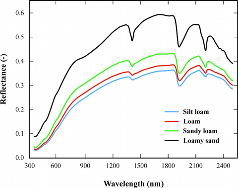
Conforti, Massimo, et al. "Visible and near infrared spectroscopy for predicting texture in forest soil: an application in southern Italy." iForest-Biogeosciences and Forestry 8.3 (2015): 339.
Water exhibits a strong absorption for energy in the NIR wavelengths, making it easily visible in imagery. In the figure below, water appears as black pixels. This strong relationship with water also applies to water-laden substances such as soil, allowing for the presence of water to be detected even while in a mixture.
Vegetation, however, exhibits the inverse relationship from water, strongly reflecting NIR radiation, appearing white in the figure below. This relationship is driven by chloroplasts in the plants’ leaves with changes in the chloroplast translating to changes in the NIR reflectance.
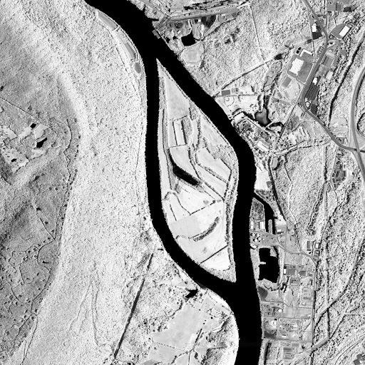
Image from Landsat 8 OLI along the Tennessee River in Late Fall 2016. Vegetation appears as white areas and water as black.
These two well-known relationships have led to a strong foundation of applications including:
- Vegetation variety mapping
- Vegetation health assessment
- Dry vs. moist soils
- Wetland, swamp, and flood mapping
At Skytec, we are putting NIR sensor technology to work in a variety of applications. If you are curious as to how our data analysts can go about these tasks in greater detail, please feel to reach out to us.
Skytec Blog

Leveraging the Latest Geospatial Technologies to Advance Wetland Identification
Launching Skytec’s Wetland Screening Tool for the State of Tennessee
Read More
Using GIS to Lead in Sustainable Supply Chain Management
At Skytec, we’re proud to partner with industry leaders like International Paper to develop innovative, GIS-based solutions that address complex challenges in sustainable sourcing and supply chain management.
Read More
Skytec Delivers Macro- to Micro-Level Data to Support Decision-Making and Planning in Architecture, Engineering & Construction
Skytec’s expertise supports architecture, engineering, and construction (AEC) firms in evaluating and monitoring development sites from conception to completion.
Read More