Blog
The Evolution of Change Detection Technology: Ranger Delivers Actionable Analytics Across Industries to Reduce Costs and Gain Efficiencies
With Skytec’s Ranger platform, you can Monitor What Matters with change detection technology to deliver ROI, solve problems, minimize downtime, and advance business.
Remote monitoring is no longer a distant reality — it’s advancing rapidly as commercial satellite imagery becomes widespread. But as remote monitoring and change detection analytics advance, how do business leaders capture the most meaningful data and analysis to inform decisions? Skytec’s Ranger platform enables companies across industries to Monitor What Matters with reliable, cost-effective data solutions that go beyond images to provide clients ROI by reducing costs, building efficiencies and minimizing downtime.
An Early Adopter and Innovator in Remote Monitoring
For almost a decade, Skytec has been an innovator in evolving technologies. Its founders broke into the UAS space and demonstrated value and delivered accurate and consistent data products to clients. The UAS solutions are supported by the team’s cutting-edge sensors and commitment to quality and aviation safety.
The remote monitoring services and Ranger platform are no different. As an early adopter of satellite imaging for change detection, Skytec anticipated the specific needs of leaders in natural resources, conservation, state and local governments, architecture, engineering and construction, and utility industries and more. Use of Ranger isn’t limited to these industries — this valuable tool can be used to monitor the progress and success of objectives virtually anywhere on Earth.
Using their combined decades of experience in GIS and data analysis, the team developed Ranger, a platform for global remote monitoring and change detection built on the Esri platform, viewed on desktop or on Esri’s ArcGIS Field Maps mobile product.
“Ranger makes ArcGIS, an already potent GIS software, more powerful. It delivers analytics so teams can be better informed at scale,” says Bill Rogers, CEO and Cofounder of Skytec. “Ranger easily integrates into investments our clients have already made with Esri. Beyond Ranger, our true, in-house GIS support and customer service for clients is a big advantage of working with Skytec.”
The Ranger Advantage
Now entering the fourth year on the market, Ranger is distinguished by its dynamic change detection among multiple areas of interest, ability to capture high-frequency change detection, and access to a variety of imaging products. Furthermore, Skytec can pair Ranger data with drone imagery captures, or integrate a client’s existing data, as needed for microscale verification.
When clients subscribe to Ranger, they get more than satellite images or tracked changes — they get the analysis and interpretation of data from Skytec’s reporting. Ranger delivers the ability to monitor many sites at scale as frequently as needed.
“Built on the Esri platform, Ranger can connect to the 350,000-plus government entities and industry organizations already on that platform,” says Andy Carroll, CTO and Cofounder of Skytec. “Our product is an extension of what clients already use, with updated data that tells you what changed, not just that there is change. We recently introduced a new subscription model that allows clients to change the area to be monitored from week to week. This enables clients to actively monitor a range of dynamic areas, such as timber harvest supply tracts, take action, and minimize potential sourcing risks.”
With Ranger, clients can expand their existing investment in Esri to:
Reduce costs with less onsite monitoring and inspection and a reduction in travel time and expenses.
Gain efficiency by monitoring more areas with fewer people and focus on potential problems before they arise.
Minimize downtime and monitor when field or site visits are restricted.
“We were very early adopters in this space to monitor change on Earth from a global scale,” Rogers says. “We’ve grown partnerships and affiliations with different imagery providers. AI and machine learning are integral parts of our solutions. We’ve fine-tuned our solutions to deliver the best results in the marketplace..”
Read more about Ranger and contact us to get started.
Skytec Blog

Utilities Can Reduce Risk and Optimize Vegetation Management with Skytec’s Remote Monitoring
Skytec combines satellite imagery and remote change detection to build 3D models or digital twins and better visualize areas of risk in vegetation management for utilities.
Read More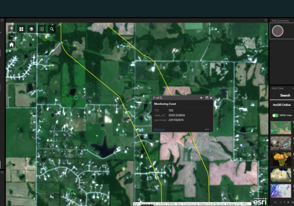
The Evolution of Change Detection Technology: Ranger Delivers Actionable Analytics Across Industries to Reduce Costs and Gain Efficiencies
With Skytec’s Ranger platform, you can Monitor What Matters with change detection technology to deliver ROI, solve problems, minimize downtime, and advance business.
Read More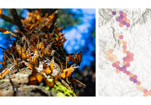
Biodiversity Monitoring and Management with Remote Change Detection
Conservation and management of biodiversity demands appropriate tools, data, and maps. Using Ranger™, Skytec guides clients across industries to monitor and manage biodiversity conservation efforts.